Communities and protected area rangers around the globe are struggling to conserve and better manage their natural resources while facing numerous threats. As the disconnect between attainable action to protect nature is ever widening, it is essential that we use technology to analyze and deliver information quickly to support conservation decisions – more quickly than forests can be destroyed. Today, in response to this ever important challenge, we at the Jane Goodall Institute are pleased to share the Forest Watcher mobile app developed in 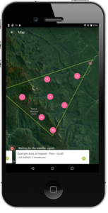 partnership with World Resources Institute and Global Forest Watch!
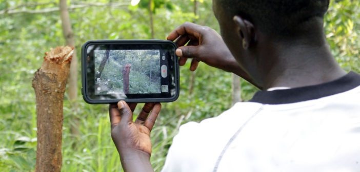
The Forest Watcher mobile app brings online forest monitoring and alert systems to more people and more places with a more efficient range of tools. An improvement to the first version of the app developed in conjunction with World Resources Institute (WRI), and Google Earth Outreach in 2016, the updated Forest Watcher mobile app brings a whole new arsenal of functionality to the table. The app delivers dynamic weekly GLAD forest loss alerts at an amazing 30 m resolution, along with other online forest monitoring and alert systems of Global Forest Watch (GFW), offline and into the field. This allows users to report instances of deforestation as well as illegal activities (including poaching) immediately.
Forest Watcher is already changing the way we at the Jane Goodall Institute protect forests, and has great potential for saving ecosystems and wildlife. Dr. Lilian Pintea, JGI’s vice-president of conservation science, shares some examples below showcasing how this new technology is benefiting our efforts:
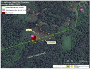
In Kibale National Park in Uganda, protecting forests means protecting chimpanzees and twelve other species of primates along with hundreds of other birds, insects, and wildlife. When the new GLAD forest loss alerts (one of the datasets used by the Forest Watcher app that identifies areas of likely tree cover loss in near real-time) successfully detected new encroached areas along the boundaries of the Kibale National Park due to illegal logging, Uganda Wildlife Authority (UWA) was not aware of these illegal activities. Thanks to these GLAD alerts from Global Forest Watch, as well as access to mobile technology and training facilitated by the Jane Goodall Institute, UWA rangers followed the alerts and confirmed the location and extent of forest loss. Park management was then able to move in to prevent further illegal logging and encroachment.

Muhikani Central Forest Reserve, locally managed by the Bunyoro kingdom in Western Uganda since 2000, used to be one of the largest natural forest and chimpanzee habitat patches in the Budongo-Bugoma corridor. Satellite imagery shows that since 2000, the reserve has been impacted by massive deforestation (see map here). GLAD forest loss alerts, as well as very high resolution of 50 cm DigitalGlobe satellite images acquired in 2017, field data, and photos collected with the Forest Watcher app, help us see the whole picture. Because of this information via Forest Watcher and satellites, it was confirmed that forest destruction continues at an alarming rate. Such maps combining near real-time satellite and field observations have the potential to bring more transparency and accountability to the land use planning and enforcement process at the local and national scales in order to hopefully prevent further loss of forest.
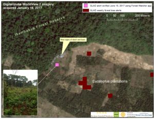
In Wambabya Central Forest Reserve, a critical forest habitat for chimpanzees and other biodiversity and an important catchment area in western Uganda, forests are shrinking. Recently, GLAD alerts and the Forest Watcher app confirmed that illegal tree cutting continues in the reserve despite protection. Very high resolution DigitalGlobe satellite images from 2017 show new signs of slash and burn encroaching into the natural forests. With this combination of satellite data and Forest Watcher ground-truthing, these activities can be reported to the local authorities and potentially stopped in near real-time in order to protect vital habitat.
Forest Watcher is enhancing our ability to learn about and act on instances of deforestation before it’s too late. All of this is done through empowering local communities and rangers to monitor their forests and report activities that are destroying habitats. The mobile app allows forest monitors to access, collect and report data on any mobile device no matter the level of internet connectivity. In remote places where conservation is of the utmost priority, this is utterly revolutionary and will allow monitors to never be held back from their work to detect illegal  activities and deforestation because of low or no connectivity. For the over 1,800 private forest owners, local communities, forest monitors and hundreds of protected area rangers working with the Jane Goodall Institute by doing their part to protect forests, this is a game changer.
Download Forest Watcher today for iOS and Android to join JGI, WRI and all of the Global Forest Watch partners in protecting forests today and for generations to come.

The Jane Goodall Institute is a global community conservation organization that advances the vision and work of Dr. Jane Goodall. By protecting chimpanzees and inspiring people to conserve the natural world we all share, we improve the lives of people, animals and the environment. Everything is connected—everyone can make a difference.


