Chimpanzees are endangered, and as threats to their survival continue to rise and expand from habitat loss, hunting and the illegal pet trade, it is crucial to have relevant and up-to-date information at scales meaningful to support conservation decisions. With support from NASA, the Jane Goodall Institute has already partnered with researchers from the Global Land Analysis and Discovery (GLAD) laboratory in the Department of Geographical Sciences at the University of Maryland to build a practical Decision Support System (DSS) to monitor from space in near-real time chimpanzee habitat health in Africa (see Jantz et al, 2016).
Now with support from a Microsoft Azure Data Science Research grant and collaboration with Microsoft’s Chief Environmental Scientist, Northern Arizona University and University of Maryland, decision makers will not only be able to see habitat status, but also to identify areas where connectivity between chimpanzee habitats will be lost in the near future if interventions are not done immediately. This will help JGI and partners to identify priority habitats and actions and avoid costly restoration work in the future.
Maintaining connectivity is an important biodiversity conservation objective beyond chimpanzees. For example, Areas of Connectivity Conservation (ACC) were recently proposed as a basis for assessing progress toward Target 11 of the Convention on Biological Diversity (IUCN 2016). Most of the existing connectivity models are fixed in time and are not designed to provide local scale information that conservation practitioners need. One of the main barriers is that connectivity modelling requires large amounts of data processing and often is limited to a couple of thousand habitat patches. Just in western Uganda alone, our preliminary estimates indicate that there are over 15,000 forest patches greater than 10 hectares that are potentially suitable for chimpanzees.

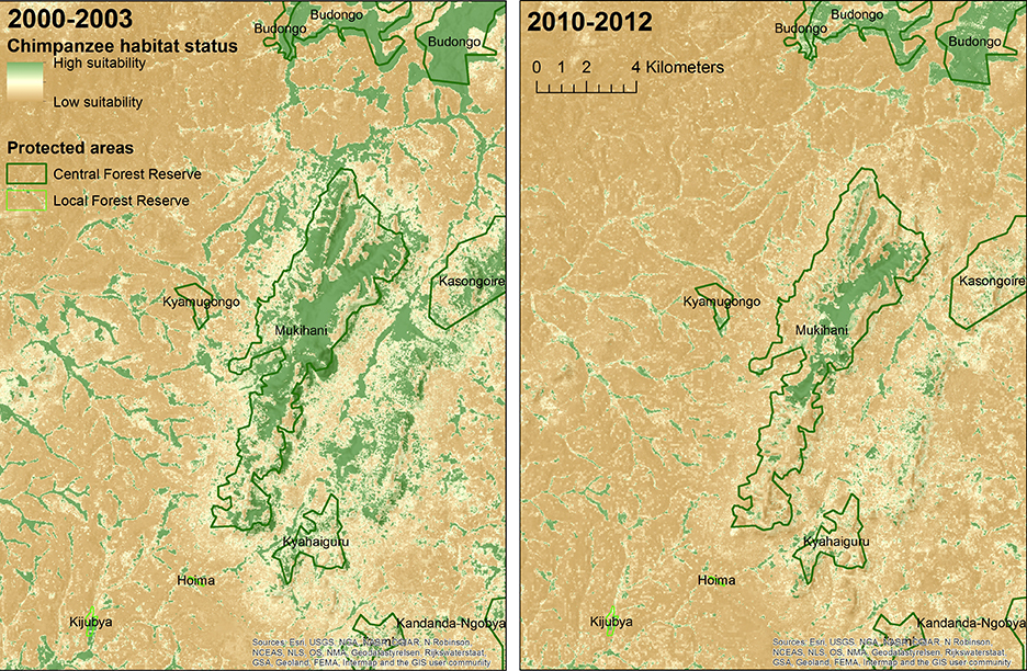
Loss in chimpanzee habitat suitability in an area of Budongo-Bugoma Corridor in western Uganda. Credit: JGI/University of Maryland/NASA.
The goal of this project is to leverage the power of Azure Cloud to model connectivity for hundreds of thousands of habitat patches and to provide critical and cost-saving information to decision-makers not only in Uganda but covering the entire chimpanzee range in Africa. If successful, this could be a breakthrough for connectivity assessments. Once layers of chimpanzee connectivity importance will be generated in Azure cloud, JGI will work with Esri to analyze, visualize, communicate and share this information through Web maps and dashboards using Esri’s ArcGIS Online platform.


